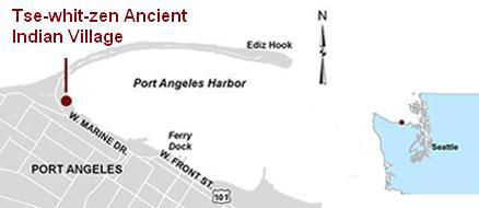
Three S'Klallam Villages Located Inside Ediz Hook, in Port Angeles Harbor
At the time of contact, there were three S’Klallam
villages located inside Ediz Hook: č̕ixʷícən (Tse-whit-zen),
located at the base of the spit, čx̣ayčáčɬč, in the area
of the Port Angeles ferry dock, and ʔiʔínəs (Ennis) at
the mouth of Ennis Creek. These villages were occupied by
S’Klallam for thousands of years until 1937, when the United
States government purchased 372 acres of land around the mouth
of the Elwha River for the use of fourteen S’Klallam families,
some of whom came from Port Angeles.
Tse-whit-zen
Already complete

The State Department of Transportation unearthed Tse-whit-zen in
August 2003, while building a dry dock on the Port Angeles,
Washington front. After spending about $60 million - and finding
335 intact skeletons - the state abandoned the project. But one of
the department's costliest mistakes has turned into an
extraordinary find: Working side by side, archaeologists and tribal
members have uncovered burials, the remains of many structures, and
signs of human activity dating back at least 2,700 years. To learn
more about the Tse-whit-zen village click on the following links:
Ennis
Ennis was a fortified S’Klallam village located at
the mouth of Ennis Creek, just east of Port Angeles. The
village was visited in 1847 by artist Paul Kane, who described
it as:
“…composed of a double row of strong pickets, the
outer ones about 20 feet high, and the inner row about five
feet, enclosing a space of 150 feet square. The whole of this
inner space is roofed in, and divided by small compartments, or
pens, for the use of each separate family. There were about 200
of the tribe in the fort at the time of my arrival.”
The village was occupied through the late 19th
century; Madge Nailor, and early inhabitant of the Puget Sound
Cooperative Colony on the west side of Ennis Creek noted that
“just east of the colony site lived Chief Norman and his wife
Sally,” who hosted a potlatch sometime in the 1890s.
Port Angeles
A third village was located along today’s Marine
Drive around the mouths of Tumwater and Valley Creeks.
Identified as an “Indian Village” site on the 1853
“Reconnaissance of False Dungeness Harbor” hydrographic chart
by the U.S. Coast Survey, this site was probably buried under
10-20 feet of fill that was used to build up the waterfront.
S’Klallam camps were common in Port Angeles as far east as
Hollywood Beach until the establishment of the Lower Elwha
Klallam Reservation in 1937.
“U.S. Coast Survey Reconnaissance of False Dungeness
Harbor Washington, by the Hydrographic Party under the command
of Lieut. James Alden U.S.N. Assist. 1853.”
|